The Kingdom of Prussia existed from 1701 to 1918 and was reigned by the Hohenzollern dynasty. The country was an absolute monarchy from its founding until 1848 and a constitutional monarchy from 1848 until its dissolution. The capital of the Kingdom of Prussia was Berlin. The land was inhabited by about 40 million people. After the November Revolution of 1918 and the abdication of Wilhelm II, the Kingdom dissolved and formed the Free State of Prussia.
In the course of the 18th century, Prussia annexed large parts of what is now Poland – including in the Silesian Wars Silesian Wars The Silesian Wars refers to three conflicts between the Kingdom of Prussia and the Habsburg monarchy. Already during the first war (1740-1742) Prussia secured most of Silesia, the second war (1744-1745) could not change this. The third war (1756-1763), was the main conflict of the Seven Years War on the European mainland. After the third war, the surrender of Silesia was officially confirmed. (1740-1763), as well as during the partitions of Poland-Lithuania partitions of Poland-Lithuania In the course of three partitions in 1772, 1793 and 1795, Poland-Lithuania was divided between the Russian Empire, Prussia and the Habsburg Monarchy and disappeared from the political map of Europe as a sovereign state until 1918. (1772-1795). The Prussian king introduced the same or similar tax systems in the former Polish territories, for example in the province of West Prussia in 1772, and here too, with a time lag, a place name law in 1775.


After the First World War, an independent Polish state emerged again after more than a hundred years. The Second Polish Republic and the Weimar Republic found themselves in competition over the legitimacy of their national territories. This conflict was also conducted through place names, among other things. By the time the Nazis seized power in 1933, some places on the German side had been renamed four times , especially in the parts of Silesia that had remained German and in East Prussia. On the Polish side, too, numerous place names were renamed or restored. As a counterpart to Germanization, Polonization was established, which in turn was supposed to prove the Polish national claim to territory. Thus, on contemporary Polish maps, the spellings Łąkocin and Inowrocław can be found for the examples already mentioned. In the Second Republic of Poland, a ‘place name commission’ was even set up in 1934, a new authority that centrally regulated decisions on the naming, renaming, and use of official place names.
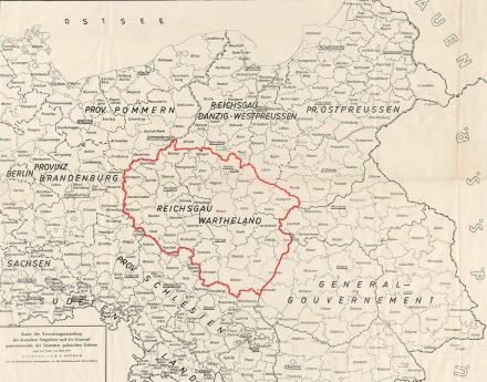
The Reichsgau Wartheland, also known as Warthegau, was a Nazi administrative district in occupied Poland that existed from 1939 to 1945. The Reichsgau was in large parts congruent with the historical landscape of Wielkopolska and had 4.5 million inhabitants. The capital was today's Poznań.
The almost six-year occupation period was characterized by the brutal persecution and murder of the Polish and Jewish population on the one hand and the targeted resettlement of German-speaking parts of the population on the other.
Image: „Map of the administrative division of the German Eastern Territories and the General Government of the occupied Polish territories as of March 1940“. Herder Institute for Historical Research on East Central Europe – Institute of the Leibniz Association, map collection, inventory no. K 32 II L 43, edited by Copernico (2022). CC0 1.0.


